


Millions are digging out after the Northeast was slammed by a powerful storm system that dropped up to 2.5 feet of snow.
If you like snow, then Lincoln's winter has been a failure so far.
The city received only 2.9 inches of the white stuff in January, which, coupled with the 0.8 inches it got in December, gives it 3.7 inches for the season.
That’s only about one-quarter the amount of snow that usually falls by the end of January. It’s also the least amount of snow at this point in the season in more than 60 years.
The last time Lincoln had so little snow by the end of January was the winter of 1960-61, when only 2.7 inches had fallen, according to the University of Nebraska-Lincoln's climate records.
Lincoln is not alone in its lack of snow. Much of eastern Nebraska has seen snow deficits of anywhere from 6 inches to more than a foot so far this winter, according to the National Weather Service.
People are also reading…
Nebraska State Climatologist Martha Shulski said a big reason why is warm, dry conditions dominating the central part of the U.S, especially extending south from Nebraska.
"For October through December of last year, Nebraska and the southern Plains has seen the warmest conditions on record," Shulski said in an email.
With no snow cover, Lincoln reached 61 degrees Monday, its third January day in the 60s. Lincoln now has recorded six straight months with above-average temperatures.
Shulski noted that early winter snowfall totals have been variable over the past several years. This is the fourth time in six years Lincoln has had less than 10 inches of snow by the end of January. The other two seasons, it had more than 25 inches.
Shulski also pointed out the longer-term trends that show Lincoln is getting warmer from November-January with slightly lower snow totals.
Late last week, forecasts were showing the possibility of significant snowfall in the Lincoln area Tuesday night into Wednesday, but those projections have now moved the storm system farther south, and the city is now forecast to receive an inch or less of snow.
The main effect of the system locally will be much-colder temperatures, with highs around 20 and lows around zero Wednesday and Thursday. Wind chills could drop to near minus 20.
The longer-term forecast calls for warmer-than-normal temperatures and below-average precipitation through the first half of February.
Shulski said conditions do not seem favorable for changing the current dry pattern in much of the state. The latest Drought Monitor from UNL shows 91% of Nebraska is abnormally dry, with 35% in some level of drought, and models are showing it's likely drought conditions will intensify in those areas this year.
Southeast Nebraska, including Lincoln, is the only place where moisture conditions are considered normal, and Shulski said soil moisture reserves in those areas "are not in a bad place."
"However, preparation and planning for a dry start to the growing season would be wise," she said."
PhotoFiles: Nebraskans tough it out during snowstorms through the years
Stuck

A Lincoln man struggles to move his car as snow continues to fall during a blizzard in 1971.
Guaranteed Snow Day

Brothers stand on top of the 15- to 20-feet-tall snowdrifts in front of their buried house 15 miles south of Chadron. This blizzard happened in March of 1966.
Jammed

Hundreds of cars and drivers were buried up to their axles in West Omaha after a blizzard dumped 11-16 inches of snow in 1975.
Mountains of Snow

A mother and child and their truck are dwarfed by drifts more than 20 feet tall after the infamous Blizzard of 1949.
Drive Safe

This snow-covered view of Lincoln in 1974 may be a somewhat familiar sight to residents after 8 inches of snow fell over the weekend.
Power Down

Utility poles and lines near David City were toppled by an icy, windy storm in 1966.
Always Prepared

A blizzard in 1978 may have ruined their fun, but the Boy Scouts of Troop #213, Chadron, sure had their skills tested when snow struck their camping trip at Fort Robinson State Park.
Cooped Up
A farmer had to dig through scores of feet of snow in order to feed his chickens after the Blizzard of 1949. The coop was completely submerged in snow.
I Thought I Could

Dozens of workers attempt to dig out a steam train stuck on the tracks after the Blizzard of 1912, putting the unshoveled sidewalks and driveways of more than a century later into sharp perspective.
Loading Up

Army National Guardsmen of the 24th Medical Co. prepare to leave Lincoln for a relief mission in western Nebraska. The area was hit hard and isolated by a blizzard in 1975.
Field Rations

The isolation of several rural communities after the Blizzard of 1949 was so bad the army had to be called in to deliver food in all-terrain, tracked vehicles.
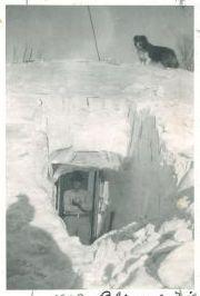
Delivery Driver

A boy and his dog are thankful for food delivered by the army after the Blizzard of 1949.
Special Delivery

Civilian pilots deliver food to rural residents near Curtis after the Blizzard of 1949. Several rural communities were completely isolated for several days after the infamous storm.
Reach the writer at 402-473-2647 or molberding@journalstar.com.
On Twitter @LincolnBizBuzz.

Matt Olberding
Associate managing editor


